GIS Day: 5 Reasons to ‘Get on the Map’
5 Reasons to ‘Get on the Map’ with Cloud GIS Software
November 16, 2016 marks the 17th annual GIS Day, dedicated to fostering the international conversation around geographic information system (GIS) technology and its real-world applications that are empowering smarter communities around the globe.
In today’s connected tech world, GIS is more important than ever. With the rapid advancement of technology and rise of cloud computing, GIS software now provides greater benefits and cost less.
In 2020, the world will generate 50 times the amount of data as in 2011 and 75 times the number of information sources (IDC, 2011).
Making sense of mounds of data
To make sense of all this information, effective presentation of data is essential. In order to communicate the significant trends and relationships affecting your community, data visualization should be part of the process, rather than an afterthought.
If a picture is worth a thousand words, a map is worth a thousand lines of data.
When it comes to local government, chances are that no matter what role you play, the data you deal with daily can be tied to a location. If you have a vision to solve a problem that your community faces today, leveraging GIS may help you push initiatives within your agency in a variety of ways.
1. Improve Communication
Being able to communicate the data you’ve acquired can be the most important part of your work. Through GIS, maps are able to communicate complex information much more effectively than raw data. By presenting information visually, GIS empowers users to highlight statistical significance, trends, and contrasting data.
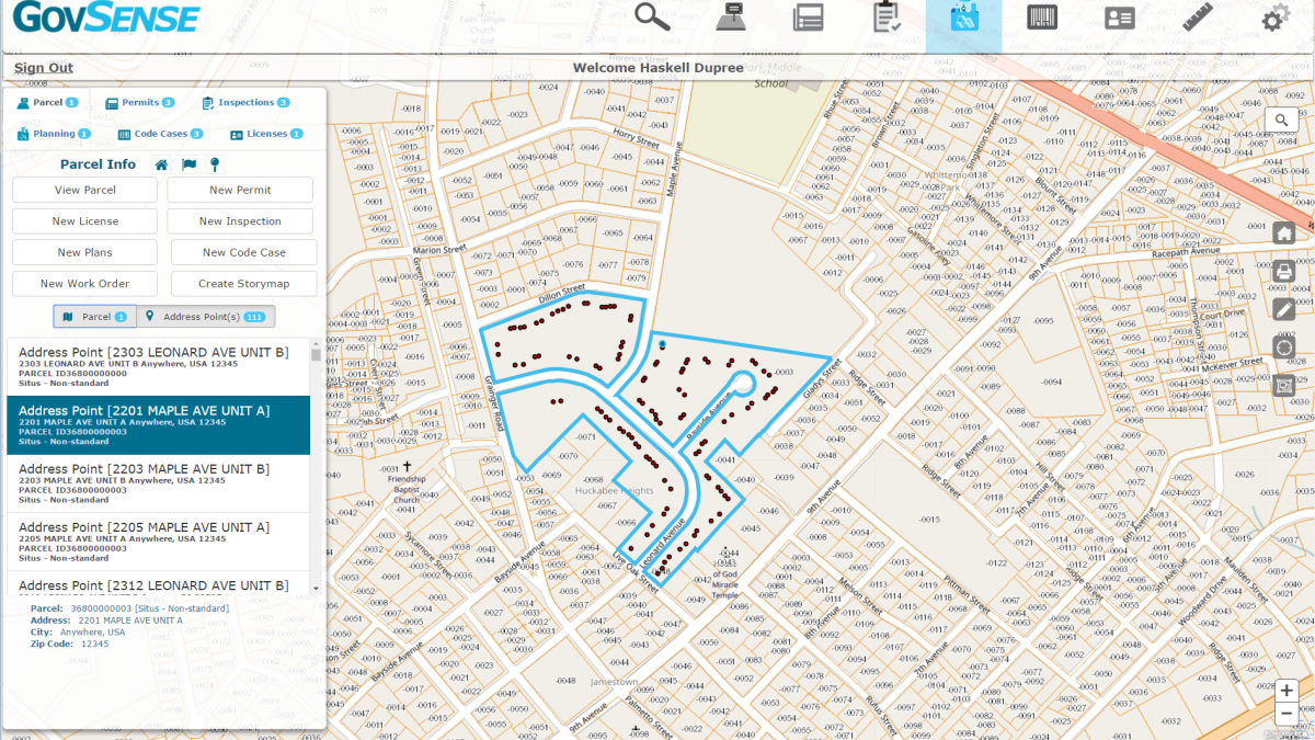
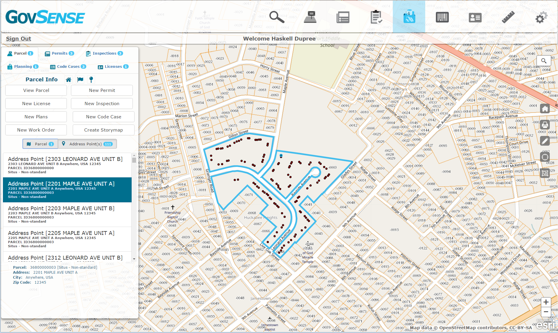
With GovSense, data is tied to spatial coordinates and essentially lives on the map. This adds a visual dimension to everything from transactions on the general ledger to land management processes including permits, business licenses, inspections, and code enforcement.
Leverage GIS to tell your story and gain buy-in from decision makers in your organization.
2. Enhance reporting capabilities
Finance departments are able to link transactions on the general ledger (GL) with their spatial location to open up new reporting possibilities. This functionality unlocks countless real world applications that communities big and small can benefit from. For instance, a planner or economic development director could calculate the return on investment of the city’s historic district by reporting on revenue generated from that area. Pair spatial and financial data to launch your community to the next level. A next-generation solution like GovSense makes it easy to identify and focus on the most valuable activities in your community.
Figure 1: Bring location-based data to your general ledger by leveraging cloud technology.
3. Foster collaboration
Siloed departments are often the biggest challenge hindering organization-wide adoption of GIS technology. GovSense is fundamentally a single unified solution. This allows all users access the same accurate, up-to-date data. Best of all, it’s easy for non-GIS users to access the map without needing requiring assistance and bandwidth from the IT department. Easily manage who sees what layers of data through built-in roles and permissions.
4. Automate tasks to save time and eliminate errors
With GovSense, your jurisdiction runs on a single cloud-based database, meaning there is one version of the truth. This eliminates cumbersome import/export processes from your workday. It also makes errors due to data discrepancies or manual data entry thing of the past.
Never waste time working on a permit that is not technically located in your jurisdiction again. Use spatial data to optimize inspection routes. Get real-time updates on the status of permit or business license applications, as well as open inspections and code cases. By leveraging cloud technology, there are countless ways to bring your plans and reports to the map view. This makes it easy to streamline operations for efficiency.
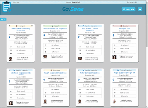
Figure 2: GovSense’s inspection storyboard view shows status updates in real time.
5. Engage constituents
With the right GIS technology, employees and citizens alike are able to interact with a user-friendly map view. Through GovSense’s citizen portal, constituents can check on the status of permit and license applications in real time. When citizens are provided instant access to data that matters to them, they will likely be more satisfied and more engaged with the community.
All in all, leveraging GIS data can empower your community to make smarter, data-driven decisions.
- Make a case for change by using maps to illustrate statistically relevant data
- Uncover patterns, diagnose problems, and predict behaviors
- Streamline processes by bringing your data to the map view
- Foster collaboration between departments
- Allow employees across the organization to work more efficiently by allowing permits, business licenses, inspections, code enforcement and more to be managed via a map view and updated in real time
- Increase citizen access & engagement
Empower your jurisdiction to become a smarter community. Click to schedule a 10-15 minute demo of GovSense’s GIS application.

About GovSense
GovSense is a land, license, permitting and financial software solution designed to enable governments to build smarter communities. Instead of having disparate systems for each department or business function, we built one system that is scalable to accomplish many local or state government tasks.

GovSense partnered with Esri to create the optimal user experience. After consulting state and local government agencies for over 7 years, we’re expanding the use of Esri technology to all aspects of local government processes, bridging gaps between previously disparate systems through the use of geographic information.
GovSense is the first complete cloud solution purpose-built for local governments, empowering over 60 communities and supporting more than 2 million citizens. Govsense built on Oracle NetSuite—the #1 true cloud ERP platform with over 50,000 customers worldwide— GovSense delivers a modern, unified system that streamlines operations, enhances transparency, and drives efficiency. GovSense’s team has been implementing cloud solutions since 2005, bringing over two decades of expertise in delivering scalable and secure technology for local agencies. As a five-time GovTech 100 recipient, we are recognized as an industry leader in transforming government technology. GovSense is one modern platform that has everything you need for your local government, ensuring your community is equipped with the tools to thrive in the digital age.